THIS COLONY LASTED ROUGHLY A YEAR FOR THE AMERICAN SETTLERS—MORE RESEARCH IS NEEDED AS NO NAMES ARE READILY DOCUMENTED. fOR THIS REASON IT IS NOT INCLUDED WITHE THE SEVEN COLONIES
A Colônia Príncipe Dom Pedro
Santa Catarina - Brasil
The Prince Dom Pedro Colony
Santa Catarina - Brazil
A Colônia Príncipe Dom Pedro foi uma colônia imperial formada com imigrantes de língua inglesa reemigrados dos Estados Unidos.
The Prince Dom Pedro Colony was an imperial colony formed with English-speaking immigrants re-emigrated from the United States.
Segundo o historiador José Ferreira da Silva (1998), a Colônia foi implantada em terras que o Governo Brasileiro adquirira de Francisco Sallenthien, que já em 1852, havia se transferido para as margens do rio Itajaí-Mirim, para adiante do Ribeirão das Águas Claras. O Governo precisava de mais terras para ampliar a Colônia e assim adquiriu a gleba de Sallenthien e outras próximas, instalado ali os imigrantes aliciados da América do Norte.
According to historian José Ferreira da Silva (1998), the Colony was implanted on land that the Brazilian Government had acquired from Francisco Sallenthien, who in 1852 had moved to the banks of the Itajaí-Mirim River, ahead of the Ribeirão das Águas Claras. The Government needed more land to expand the Colony and so it acquired the land of Sallenthien and others nearby, settling the immigrants enticed from North America.
A data da Fundação
Em 19 de janeiro de 1866, o Decreto Imperial criou, oficialmente, a Colônia Príncipe Dom Pedro, também à margem do Itajaí-Mirim, só que à direita, justamente na confluência do ribeirão das Águas Claras sobre aquele rio, poucos quilômetros acima da sede da Colônia Brusque. Mas, de acordo com Aloisius C. Lauth (2014), os administradores usaram diferentes datas para marcar o início da Colônia. Para uns, seria o dia 19 de janeiro de 1867, quando o Decreto nº. 3784 aprovou o Regulamento para as Colônias do Estado. Para outros, seria o dia 15 de fevereiro de 1867, quando da chegada da primeira leva de norte-americanos (aliciados pela Companhia de Navegação “United States and Brazil Steamship” ao Barracão dos Imigrantes em Brusque. Para outros, seria o dia 1º de março de 1867, quando da emissão dos primeiros atos administrativos que confirmariam a intenção do Governo Imperial de fundar a Colônia. De acordo com Lauth, a data mais adequada para ser o marco da fundação da Colônia Príncipe Dom Pedro seria o dia 10 de março de 1867, pois foi nesse dia que se realizou o primeiro acampamento dos imigrantes norte-americanos no barracão provisório de Águas Claras.
The Date of Foundation
On January 19, 1866, the Imperial Decree officially created the Prince Dom Pedro Colony, also on the banks of the Itajaí-Mirim, but on the right, precisely at the confluence of the Águas Claras stream on that river, a few kilometers above the headquarters of the Brusque Colony. But, according to Aloisius C. Lauth (2014), the administrators used different dates to mark the beginning of the Colony. For some, it would be January 19, 1867, when Decree No. 3784 approved the Regulation for the State Colonies. For others, it would be February 15, 1867, when the first wave of Americans arrived (enticed by the United States and Brazil Steamship Shipping Company) at the Immigrants' Shed in Brusque. For others, it would be March 1, 1867, when the first administrative acts were issued that would confirm the intention of the Imperial Government to found the Colony. According to Lauth, the most appropriate date to mark the foundation of the Príncipe Dom Pedro Colony would be March 10, 1867, because it was on that day that the first encampment of North American immigrants was held in the temporary shed of Águas Claras.
O transporte de Itajaí e a chegada em Brusque
O Diretor Dr. Barzillar Cottle foi o primeiro diretor da Colônia Príncipe Dom Pedro e fretou várias embarcações a remo e transportou os imigrantes rio acima da barra do Porto de Itajaí até o Barracão dos Imigrantes em Brusque.
Transportation from Itajaí and arrival in Brusque
Director Dr. Barzillar Cottle was the first director of the Príncipe Dom Pedro Colony and chartered several rowing boats and transported the immigrants upstream from the Port of Itajaí to the Immigrants' Shed in Brusque.
Antes, um ofício de 9 de fevereiro de 1867, expedido pelo Presidente da Província de Santa Catarina, solicitava ao Barão Maximilian von Schneeburg, Diretor da Colônia Itajahy-Brusque, que fizesse descer “as duas canoas da Diretoria e todas as lanchas de particulares que V. S.ª puder alugar para este feito (...) para conduzir colonos agora mesmo chegados”. E lhe aconselhava o Presidente da Província que estivesse “pronto para receber até 190 colonos no Barracão dessa Colônia, destinado a semelhante mister”.
Earlier, a letter dated February 9, 1867, issued by the President of the Province of Santa Catarina, requested Baron Maximilian von Schneeburg, Director of the Itajahy-Brusque Colony, to lower "the two canoes of the Board of Directors and all the private boats that you can rent for this purpose (...) to lead settlers who have just arrived." And the President of the Province advised him to be "ready to receive up to 190 settlers in the Shed of this Colony, destined for such a task".
O grupo de imigrantes ingleses com os quais o Governo Imperial deu início à colônia agrícola Príncipe Dom Pedro chegou ao Brasil a bordo do Vapor Tartar. Em 08/02/1867, de acordo com o Jornal “O Despertador’ (SC), o Vapor Lima e Silva, desembarcou 120 indivíduos que vieram dos Estados Unidos da América. A intenção do Governo Imperial era trazer correntes migratórias de mão de obra livre e, acima de tudo, de mentalidade liberal e progressista, semelhante à migração aos Estados Unidos.
The group of English immigrants with whom the Imperial Government started the agricultural colony Prince Dom Pedro arrived in Brazil aboard the Steamship Tartar. On 02/08/1867, according to the newspaper "O Despertador" (SC), the Vapor Lima e Silva, disembarked 120 individuals who came from the United States of America. The intention of the Imperial Government was to bring migratory currents of free labor and, above all, of liberal and progressive mentality, similar to migration to the United States.
A demarcação dos Lotes
A distância entre o barracão dos imigrantes da Colônia Príncipe Dom Pedro e o barracão da Colônia Itajahy-Brusque era de cerca de 4 km.
The demarcation of Lots
The distance between the shed of the immigrants of the Príncipe Dom Pedro Colony and the shed of the Itajahy-Brusque Colony was about 4 km.
A jornada de exploração e o levantamento topográfico da colônia começaram logo após a chegada dos ingleses reemigrados dos Estados Unidos ao barracão dos imigrantes. Uma parte abriu uma clareira na mata. Reconhecida a região, e com as informações prestadas pelo Barão von Schneeburg, Diretor da Colônia Itajahy-Brusque, ao Dr. Cottle, Diretor da Colônia Príncipe Dom Pedro, este definiu as trilhas de acesso a partir de um porto aberto na foz do Ribeirão Águas Claras e outro em Pedras Grandes, até onde os barcos a remo poderiam navegar. Também foi preciso abrir uma picada do porto do ribeirão ao barracão coletivo, distante aproximadamente 1,2 km.
The journey of exploration and the topographic survey of the colony began soon after the arrival of the English reemigrants from the United States to the immigrants' shed. One part opened a clearing in the forest. Once the region was recognized, and with the information provided by Baron von Schneeburg, Director of the Itajahy-Brusque Colony, to Dr. Cottle, Director of the Príncipe Dom Pedro Colony, he defined the access trails from an open port at the mouth of the Águas Claras Stream and another in Pedras Grandes,to where rowing boats could navigate. It was also necessary to open a trail from the port of the stream to the collective shed, approximately 1.2 km away.
O território da colônia Príncipe Dom Pedro era cortado pelo Ribeirão Águas Claras, Limeira, Limoeiro, Cedro Grande, Cedro Pequeno, Alferes e Creeker. Acima da foz do Ribeirão Águas Claras, a área era menos acidentada e não estava sujeita a tantas enchentes do rio. Os primeiros lotes coloniais foram demarcados a partir dos ribeirões, abrangendo, em média, 30 hectares cada.
The territory of the Príncipe Dom Pedro colony was crossed by the Águas Claras, Limeira, Limoeiro, Cedro Grande, Cedro Pequeno, Alferes and Creeker streams. Above the mouth of the Águas Claras Stream, the area was less rugged and was not subject to as much flooding from the river. The first colonial lots were demarcated from the streams, covering an average of 30 hectares each.
Formaram-se os primeiros grupos de serviço assalariado, pagos por jornada diária. Outro grupo ocupou-se da abertura de picada para a Encruzilhada de Águas Claras e para o lugar chamado Rodger’s Road, na região de Cedro Grande. Uma picada se ria aberta da sede da Colônia Príncipe Dom Pedro na direção das terras de Paul Kellner e Pedro José Werner, antigos moradores, proprietários de terras em Pedras Grandes.
The first groups of salaried service were formed, paid by the day. Another group took care of the opening of the trail to the Crossroads of Águas Claras and to the place called Rodger's Road, in the region of Cedro Grande. A trail opened from the headquarters of the Príncipe Dom Pedro Colony in the direction of the lands of Paul Kellner and Pedro José Werner, former residents, landowners in Pedras Grandes.
A frustração do Diretor em relação ao território.
Já nos primórdios da demarcação, em 1867, a Diretoria da colônia se dirigiu à Presidência da Província, reclamando que “o terreno que foi destinado para esta colônia, segundo a descrição feita pelo engenheiro que a demarcou, devia conter boas terras para a cultura; as explorações, porém, ultimamente feitas, por ocasião da divisão dos lotes, não confirmaram aquela informação, encontrando-se em quase toda parte estreitos e montanhas escarpadas, que não se prestam à cultura, principalmente pelo arado; as melhores terras estão dentro da área pertencente a Sallenthien, que fica entre o primeiro território da Colônia Itajahy e o segundo, que também lhe estava destinado, mas que foi designado para a nova colônia”. Ou seja, as melhores áreas estavam localizadas justamente nas terras particulares de Paul Kellner e de Franz Sallenthien que, naquele momento, as usavam para exploração de madeira e cujas terras estavam encravadas no seio do território incorporado à Colônia Príncipe Dom Pedro. (LAUTH, 2014).
The Director's frustration with the territory.
Already in the early days of the demarcation, in 1867, the colony's Board of Directors addressed the Presidency of the Province, complaining that "the land that was destined for this colony, according to the description made by the engineer who demarcated it, should contain good land for cultivation; the explorations, however, recently made, at the time of the division of the lots, have not confirmed this information, and almost everywhere there are straits and steep mountains, which do not lend themselves to cultivation, especially by the plough; the best lands are within the area belonging to Sallenthien, which is between the first territory of the Itajahy Colony and the second, which was also destined for it, but which was assigned to the new colony". In other words, the best areas were located precisely on the private lands of Paul Kellner and Franz Sallenthien who, at that time, used them for logging and whose lands they were located within the territory incorporated into the Príncipe Dom Pedro Colony. (LAUTH, 2014).
Vencidas as dificuldades iniciais, um bom trecho de caminhos foi aberto para o trânsito de veículos de tração, e outros apenas para pessoas e animais de carga. Um caminho de carroças ligava as colônias Itajahy-Brusque e Príncipe Dom Pedro. Tendo em vista a grande utilidade proveniente da ligação direta com a capital, que viria a facilitar o intercâmbio comercial, o Presidente da Província de Santa Catarina, Dr. Adolfo de Barros Cavalcanti de Albuquerque Lacerda, autorizou, em 1867, a abertura de uma picada até o núcleo de Tijucas. O trabalho de abertura era realizado pelos imigrantes e pago com recursos públicos.
Once the initial difficulties were overcome, a good stretch of roads was opened for the transit of traction vehicles, and others only for people and pack animals. A cart path connected the colonies of Itajahy-Brusque and Príncipe Dom Pedro. In view of the great usefulness of the direct connection with the capital, which would facilitate commercial exchange, the President of the Province of Santa Catarina, Dr. Adolfo de Barros Cavalcanti de Albuquerque Lacerda, authorized, in 1867, the opening of a trail to the center of Tijucas. The opening work was carried out by immigrants and paid for with public resources.
A Colônia Príncipe Dom Pedro foi instalada à margem direita do rio Itajaí-Mirim, divisando com a Colônia Itajahy. Inicialmente, as terras foram utilizadas para instalação de elementos ingleses e irlandeses reemigrados dos Estados Unidos, que permaneceram por pouco tempo. Segundo José Ferreira da Silva (1972), essa Colônia não prosperou já que, logo de início, foi mal administrada pelo seu diretor que foi demitido e processado por desvio de dinheiro e outras irregularidades. A duração da Colônia foi efêmera e, em 1869, foi anexada à Colônia Itajahy. Depois suas terras foram utilizadas para instalação de colonos poloneses e, mais tarde, por italianos.
The Príncipe Dom Pedro Colony was installed on the right bank of the Itajaí-Mirim River, bordering the Itajahy Colony. Initially, the lands were used for the installation of English and Irish elements re-emigrated from the United States, who stayed for a short time. According to José Ferreira da Silva (1972), this Colony did not prosper since, from the beginning, it was badly managed by its director who was fired and prosecuted for embezzlement of money and other irregularities. The duration of the Colony was ephemeral and, in 1869, it was annexed to the Itajahy Colony. Later its lands were used for the installation of Polish settlers and, later, by Italians.
O Fracasso da Colonização
A Colônia Príncipe Dom Pedro custava a se desenvolver. Os imigrantes ingleses e irlandeses, que haviam sido assentados no território, eram avessos ao trabalho na terra e logo se tornaram pensionistas do governo. Dependiam do trabalho na abertura de estradas, que era pago por diária. Nem sempre havia dinheiro do governo para contratação dos serviços e logo passaram à ociosidade. Surgiram inúmeros desacertos e distúrbios entre os imigrantes.
The Failure of Colonization
The Príncipe Dom Pedro Colony was slow to develop. The English and Irish immigrants, who had been settled in the territory, were averse to working the land and soon became government pensioners. They depended on the work in opening roads, which was paid per day. There was not always money from the government to hire the services and soon they became idle. Numerous misunderstandings and disturbances arose among the immigrants.
Má gestão pública também foi verificada. Com o fracasso da colonização, aos poucos a área foi sendo abandonada. Apesar de ser área montanhosa e pouco propícia ao plantio da lavoura com arado, o território era de grande riqueza florestal e havia muitos cursos d’água. Suas dificuldades em termos de áreas propícias à agricultura eram semelhantes a outras regiões do estado de Santa Catarina. O que faltou foi administração e vontade de trabalhar. Conforme dizia Ayres Gevaerd, as administrações da Colônia Príncipe Dom Pedro foram incapazes de promover o seu êxito, apesar de bem intencionadas.
Public mismanagement was also verified. With the failure of colonization, little by little the area was abandoned. Despite being a mountainous area and not very conducive to planting crops with plows, the territory was of great forest wealth and there were many watercourses. Its difficulties in terms of areas suitable for agriculture were similar to other regions of the state of Santa Catarina. What was lacking was administration and willingness to work. As Ayres Gevaerd said, the administrations of the Príncipe Dom Pedro Colony were incapable of promoting its success, despite being well-intentioned.
Segundo Jacintho Antônio de Mattos (1917) “aos poucos, esses colonos (ingleses e irlandeses reemigrados dos Estados Unidos) foram deserdando dos seus lotes. A 6 de dezembro de 1869, a Colônia Príncipe D. Pedro foi extinta pelo Governo Imperial, anexando o seu território ao da Colônia Itajahy.
According to Jacintho Antônio de Mattos (1917) "little by little, these settlers (English and Irish reemigrated from the United States) were disinherited from their lots. On December 6, 1869, the Príncipe D. Pedro Colony was extinguished by the Imperial Government, annexing its territory to that of the Itajahy Colony.
Estatística de imigrantes encaminhados para a colônia Príncipe Dom Pedro pela Agência, Oficial de Colonização, no Rio de Janeiro, no período de 1867 a 1869.
Statistics of immigrants sent to the Príncipe Dom Pedro colony by the Colonization Official Agency, in Rio de Janeiro, in the period from 1867 to 1869.
Imigrantes - anos
Em 1867: 108 ingleses; 237 americanos; 129 irlandeses; 61 alemães; 76 franceses; 10 italianos; 01 escocês; 05 suíços; 04 belgas; 02 espanhóis; 08 suecos; 29 outros.
Em 1868: 249 ingleses, 22 americanos; 114 irlandeses; 37 alemães; 06 franceses; 04 italianos; 03 escoceses; 04 suíços; 07 holandeses; 01 sueco; 03 outros.
Em 1869: 13 ingleses; 03 irlandeses; 05 escoceses.
Annual Immigration
In 1867: 108 English; 237 Americans; 129 Irish; 61 Germans; 76 French; 10 Italians; 01 Scottish; 05 Swiss; 04 Belgians; 02 Spaniards; 08 Swedes; 29 others.
In 1868: 249 English, 22 Americans; 114 Irish; 37 Germans; 06 French; 04 Italians; 03 Scots; 04 Swiss; 07 Dutch; 01 Swedish; 03 others.
In 1869: 13 English; 03 Irish; 05 Scots.
O Barracão dos Imigrantes
The Immigrants' Barracks
Recepção dos imigrantes na Barra do Itajahy. Acervo: Rosemari Glatz
Reception for immigrants was in the Itajahy neighborhood. Rosemari Glatz Archive
Nas colônias instaladas no estado de Santa Catarina a partir da segunda metade do século XIX, os imigrantes que chegavam para colonizar o território eram acolhidos nas chamadas “Casas de Imigração”. Os imigrantes que aportavam no Ancoradouro das Cabeçudas, em Itajaí, inicialmente eram acolhidos na casa de recepção, que ficava na Barra do Rio. Ao chegar em terra firme, antes de seguir viagem para a Colônia, os colonizadores descansavam alguns dias no barracão dos imigrantes. O percurso até a colônia onde seriam instalados era feito pelo rio, usando botes, lanchões e canoas impulsionadas por remo.
In Colonies begun in the state of Santa Catarina after the second half of the nineteenth century, immigrants who arrived to colonize the territory were welcomed at so-called "Immigration Houses". Immigrants who docked at the Ancoradouro das Cabeçudas, in Itajaí, were initially welcomed at the reception house, which was located in the riverfront neighborhood. Upon arriving on dry land, before continuing their journey to the Colony, the colonizers rested for a few days in the immigrants' shed. The route to the colony where they would be settled was made by the river, using boats, boats and canoes propelled by oars.
O primeiro barracão da Colônia Itajahy-Brusque, ou “Casa da Imigração” foi construído em 1860, bem próximo do rio Itajaí-Mirim. Era o espaço destinado à recepção e hospedagem dos colonizadores.
The first barracks for the Itajahy-Brusque Colony, or "House of Immigration" was built in 1860, very close to the Itajaí-Mirim River. It was the space intended for the reception and lodging of the colonizers.
Durante o tempo de preparação do espaço que receberia a família, mulheres e crianças ficavam instaladas no Barracão dos Imigrantes. O trabalho de ocupação das terras era feito em mutirão, também chamado de “pixurum”, com grupos de homens abrindo as picadas, os claros na floresta nativa, derrubando as árvores, delimitando os lotes e neles construindo as primeiras casas provisórias, para que as famílias dos imigrantes se instalassem provisoriamente. Os primeiros lotes coloniais foram demarcados a partir dos rios e ribeirões, abrangendo, em média, 25 a 30 hectares cada lote.
During preparation for the space that would receive the family, women and children were housed in the Immigrants' Barracks. Work to occupying land was done as a collective effort, also called "pixurum", with groups of men opening trails, clearing native forest, cutting down the trees, delimiting lots and building the first temporary houses on them, so immigrant families could settle temporarily. The first colonial lots were demarcated from the rivers and streams, covering, on average, 25 to 30 hectares each lot.
Poucos anos depois, em 1867, foi construído mais um barracão, este para acolher os imigrantes destinados à Colônia Príncipe Dom Pedro. Ali, em março daquele mesmo ano, aconteceu o primeiro acampamento dos colonizadores no barracão provisório de Águas Claras.
A few years later, in 1867, another barrack was built, this one to welcome the immigrants destined for the Príncipe Dom Pedro Colony. There, in March of that same year, the first camp of the colonizers took place in the temporary barack at Águas Claras.
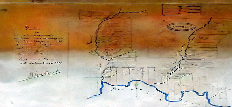
Mapa da Colônia Príncipe Dom Pedro com demarcação de lotes. Acervo: SAB
Map of the Príncipe Dom Pedro Colony with demarcation of lots. Collection: SAB
Mapa antigo de Colônia Príncipe Dom Pedro - Mapa antigo de Colônia Príncipe Dom Pedro
Old map of Colônia Príncipe Dom Pedro - Old map of Colônia Príncipe Dom Pedro
Acervo Museu Casa de Brusque - Casa de Brusque Museum Archive
Mapa da Colônia Príncipe Dom Pedro. A Colônia Príncipe Dom Pedro foi criada em 16 de janeiro de 1866, e instalada à margem direita do rio Itajaí-Mirim, fazendo divisa com a Colônia Itajahy. Recebeu imigrantes americanos, ingleses e de outras etnias. Esses novos colonos permaneceram pouco tempo na região, pois as promessas feitas não foram cumpridas, o que gerou insatisfação e revoltas. As terras dessa colônia foram utilizadas para instalação de colonos poloneses em 1869 e italianos a partir de 1875, que anos mais tarde deram origem aos municípios de Nova Trento, Vidal Ramos, Botuverá e Presidente Nereu. Este é um antigo mapa da Colônia Príncipe Dom Pedro, produzido pelo agrimensor (medidor de terras) Germano Thieme. É possível identificar o traçado do rio Itajaí-Mirim e do ribeirão Águas Claras, como também das linhas que demarcavam os lotes coloniais. Texto adaptado do Colecionável de 152 de Anos de Brusque publicado pelo Jornal O Município.
Map of the Príncipe Dom Pedro Colony. The Príncipe Dom Pedro Colony was created on January 16, 1866, and installed on the right bank of the Itajaí-Mirim River, bordering the Itajahy Colony. It received American, English and other ethnic immigrants. These new settlers remained in the region for a short time, as the promises made were not fulfilled, which generated dissatisfaction and revolts. The lands of this colony were used for the installation of Polish settlers in 1869 and Italian settlers from 1875 onwards, who years later gave rise to the municipalities of Nova Trento, Vidal Ramos, Botuverá and Presidente Nereu. This is an old map of the Príncipe Dom Pedro Colony, produced by the surveyor (land meter) Germano Thieme. It is possible to identify the route of the Itajaí-Mirim river and the Águas Claras stream, as well as the lines that demarcated the colonial lots. Text adapted from the 152 Years of Brusque Collectible published by the newspaper O Município.
REFERÊNCIAS
CABRAL, Oswaldo R. Brusque: Subsídios para a história de uma colônia nos tempos do Império. Brusque: Edição da Sociedade Amigos de Brusque comemorativa do 1º Centenário da Fundação da Colônia, 1958.
LAUTH, Aloisius C. Colonos Ingleses em Águas Claras. 2014.
MATTOS, Jacintho Antônio de. Colonização do Estado de Santa Catarina: dados históricos e estatísticos, 1917.
NIEBUHR, Marlus. Organizador. Brusque 150 Anos: Tecendo uma História de Coragem. Fundação Cultural de Brusque, 2012
SILVA, José Ferreira da. História de Blumenau. Florianópolis: Editora EDEME - Empreendimentos Educacionais Ltda., 1972.
SILVA, José Ferreira da. Blumenau em Cadernos.1998.
Brusque Memórias. Disponível em:<http://www.brusquememoria.com.br>. Acesso em 16 de agosto de 2018.
REFERENCES
CABRAL, Oswaldo R. Brusque: Subsidies for the history of a colony in the times of the Empire. Brusque: Edition of the Friends of Brusque Society commemorating the 1st Centenary of the Foundation of the Colony, 1958.
LAUTH, Aloisius C. English Settlers in Águas Claras. 2014.
MATTOS, Jacintho Antônio de. Colonization of the State of Santa Catarina: historical and statistical data, 1917.
NIEBUHR, Marlus. Organizer. Brusque 150 Years: Weaving a Story of Courage. Brusque Cultural Foundation, 2012
SILVA, José Ferreira da. History of Blumenau. Florianópolis: Editora EDEME - Empreendimentos Educacionais Ltda., 1972.
SILVA, José Ferreira da. Blumenau in Cadernos.1998.
Brusque Memories. Available at:. Accessed on August 16, 2018.



Sideways view of above Map number 2

Mapa da Colônia Itajahy-Brusque
Em 1867 foi fundada a Colônia Príncipe Dom Pedro, que estava situada a 6 km do porto das canoas (sede de Brusque), na rodovia Brusque D. Joaquim, após o morro da Souza Cruz, na confluência do ribeirão Águas Claras com o Itajaí-Mirim. Colonos de diversas nacionalidades, trazidos da América do Norte, ocuparam a região. Este centro de colonização não deu certo devido à falta de organização do Governo. Como consequência, a maioria dos imigrantes seguiu para outras regiões e o território da colônia foi anexado à Colônia Itajahy-Brusque em 6 de dezembro de 1869. No mesmo local, tentou-se a fixação de colonos poloneses, também sem muito êxito. A partir de 1875, o território foi ocupado pelos imigrantes italianos. Texto adaptado do Álbum de Figuras 150 Anos de Brusque do Jornal O Município.
Map of the Itajahy-Brusque Colony
In 1867 the Príncipe Dom Pedro Colony was founded, which was located 6 km from the port of Canoas (Brusque's headquarters), on the Brusque D. Joaquim highway, after the Souza Cruz hill, at the confluence of the Águas Claras stream with the Itajaí-Mirim. Settlers of different nationalities, brought from North America, occupied the region. This colonization center did not work due to the lack of organization of the Government. As a consequence, most of the immigrants went to other regions and the territory of the colony was annexed to the Itajahy-Brusque Colony on December 6, 1869. In the same place, an attempt was made to settle Polish settlers, also without much success. From 1875, the territory was occupied by Italian immigrants. Text adapted from the Album of Figures 150 Years of Brusque of the newspaper O Município.

IRISH PERSPECTIVE
Brazil and Ireland
By Edmundo Murray
The first Irish settler in Brazil was a missionary, Thomas Field S.J. (1547-1626), born in Limerick, who entered the Jesuit Order in Rome in 1574. Fr. Field arrived in Brazil in late 1577 and spent three years in Piratininga (present-day São Paulo). He then moved to Paraguay in the company of two other Jesuits, and over the next ten years they established missions among the Guaraní people. Thomas Field, who died in Asunción, is credited with being the first Irish priest to celebrate the Roman Catholic rites in the Americas.
Around 1612 the Irish brothers Philip and James Purcell established a colony in Tauregue, at the mouth of the Amazon river, where English, Dutch, and French settlements were also established. Huge profits were made by the colonists from trading in tobacco, dyes, and hardwoods. A second group arrived in 1620 led by Bernardo O'Brien of County Clare. They built a wood and earthen fort on the north bank of the Amazon and named the place Coconut Grove. O'Brien learned the dialect of the Arruan people, and his colleagues became expert navigators of the maze of tributaries, canals and islands that form the mouth of the Amazon. The first recorded Saint Patrick's Day celebration was on 17 March 1770 at a church built in honour of the saint by Lancelot Belfort (1708-1775). The church was located on his estate, known as Kilrue, beside the Itapecurú River in the state of Maranhão in northern Brazil.
Several Irish soldiers served in Brazilian armies, including Diago Nicolau Keating, Diago O'Grady, and Jorge Cowan. Another Irish military man, William Cotter, was sent to Ireland in 1826 to recruit a regiment for service against Argentina. Cotter went to County Cork where he promised the local people that if they enlisted they would be given a grant of land after five years' service. He left for Rio de Janeiro in 1827 with 2,400 men and some of their wives and children, but they were completely neglected when they arrived. The Irish mutinied together with a German regiment, and for a few days there was open warfare on the streets of Rio de Janeiro. While most were ultimately sent home or re-emigrated to Canada or Argentina, some did stay and were sent to form a colony in the province of Bahia.
In the 1850s the Brazilian government was anxious to raise agricultural production and to increase the population of its southern provinces, in particular with northern European immigrants. After German and Swiss governments imposed restrictions on emigration to Brazil as a consequence of the poor conditions that many of these countries' citizens had experienced there, Brazil turned its attention to other possible sources of immigrants. Fr. T. Donovan, an Irish Catholic priest, led up to four hundred people from the County Wexford barony of Forth to Monte Bonito, near Pelotas in the then province of Rio Grande do Sul. The Irish colony rapidly collapsed, and most of the survivors made their way to Argentina or Uruguay, complaining of the lack of preparations for their reception, the lack of agricultural tools, poor land, scarce water, and of the local diet.
Further colonisation schemes in Brazil were also a failure. In 1867 Quintino Bocayuva, a Brazilian newspaper editor and future republican leader, was sent to New York by the Brazilian government to recruit immigrants. His mission was to sign up former Confederates, but to help fill the ships he also dispatched several hundred poverty-stricken Irish. Most of these were sent to Colônia Príncipe Dom Pedro, near present-day Brusque in the province of Santa Catarina. Fr. Joseph Lazenby, an Irish Jesuit living in the provincial capital, made his way to Príncipe Dom Pedro and declared that he would develop the village into an Irish Catholic colony. Lazenby soon got in contact with Fr. George Montgomery, an Irish Catholic priest in the English 'Black Country' town of Wednesbury, who arranged in 1868 for some three hundred of his parishioners to be sent to Brazil. Montgomery maintained that the Irish had no future in England and saw in Brazil an opportunity to create Irish Catholic communities. He firmly believed that thousands more Irish living in England would soon be joining the first emigrants. However, within just two years the new Irish colony had failed. It was located far from any possible markets and its land was vulnerable to flooding. Many of the immigrants died, and the survivors moved on to other parts of Brazil, Argentina and the United States, or returned to England.
Irish immigration to Brazil was also the main objective of the Anglo-Brazilian Times newspaper, published weekly by William Scully in Rio de Janeiro between 1865 and 1884. Scully was also the founder of the 'Sociedade Internacional de Imigraçao' in 1866, which represented his material support to the Brazilian government.
Irish diplomats served British interests in Brazil. Daniel Robert O'Sullivan (1865-1921), medical doctor, army officer, and diplomat, whose career was largely spent in East Africa and Brazil, served as British consul or consul-general in Bahia (1907), São Paulo (1910), and Rio de Janeiro (1907-1908, 1913-1915, 1919-1921). The Irish patriot Roger Casement (1864-1916) was a British consular official in Brazil in 1906-1911. In 1906 Casement was appointed consul in Santos and in 1908 he became the consul in Pará (Belém). He was promoted to consul-general in Rio de Janeiro in 1909, a position he retained until 1913. In 1910 Casement was directed by the Foreign Office to occupy a commission of enquiry sent to the rubber-producing Putumayo region of the western Amazon, an area straddling the Peruvian-Colombian frontier, to investigate treatment of the local Indian population by the Peruvian Amazon Company. He was knighted in 1911 for this and for similar work in Africa. During the First World War Casement sided with Germany as a tactic to promote Irish independence, and in 1916 he was hanged by the British for treason. To damage his reputation, the British publicised the existence of Casement's diaries, which included numerous graphic and coded accounts of his homosexual activities in Brazil and elsewhere.
In 1964 Michael J. Siejes was appointed as the first honorary consul of Ireland in Rio de Janeiro, and later Pádraig de Paor was appointed non-resident Irish ambassador accredited to Brazil. In September 1975 an Irish trade mission led by Robin Bury visited São Paulo and Rio de Janeiro. The Irish diplomatic mission was established in Brazil in 1975, and Brazil opened its embassy in Dublin in 1991. The first resident Irish ambassador to Brazil, Martin Greene, arrived in Brasília in December 2001.
In Latin America, Brazil is Ireland’s second most important trading partner after Mexico, with an average of US$154 million in exports and US$80 million in imports per annum in 1996-2002 (International Monetary Fund, Direction of Trade Statistics, Yearbook 2003). In 1999 Kerry do Brasil was the first major Irish company to set up in Brazil with a US$20 million investment in a production plant in Três Corações.
There are a significant number of missionary undertakings by Irish religious orders in Brazil. The Redemptorists established themselves in Brazil in 1960, the Kiltegans in 1963, and the Holy Ghosts in 1967. In 2004, John Cribbin O.M.I., of Shanagolden, County Limerick, was awarded honorary citizenship of Rio de Janeiro for his work there since 1962.
Among the academic initiatives in the region, since 1999 the Associação Brasileira de Estudos Irlandeses at the University of São Paulo has been publishing the ABEI Journal: The Brazilian Journal of Irish Studies, edited by Munira H. Mutran and Laura P.Z. Izarra. The University of São Paulo has offered a postgraduate course on Irish literature since 1977.
By the end of 2000, it was estimated that 925 Irish citizens were living in Brazil, 64 per cent of them in São Paulo, Rio de Janeiro, and Bahia. In Ireland, one of the most significant Latin American communities is that of the Brazilians in counties Galway and Roscommon dating back to 1999. Most hail from the countryside near Anápolis in the state of Goiás and arrived equipped with experience in working in slaughterhouses in Brazil. A large number of Brazilians have also recently settled in Dublin City and in Naas, County Kildare.
Edmundo Murray
Adapted from: Jim Byrne, Philip Coleman and Jason King (eds.), Ireland and the Americas: Culture, Politics and History (Santa Barbara, CA: ABC-CLIO, forthcoming 2006), with kind permission of the publisher.
References
- Marshall, Oliver, English, Irish and Irish-American Pioneer Settlers in Nineteenth-Century Brazil (Oxford: Centre for Brazilian Studies, University of Oxford, 2005).
- Marshall, Oliver, Brazil in British and Irish Archives (Oxford: Centre for Brazilian Studies, University of Oxford, 2002).
- O'Neill, Peter, 'Links between Brazil and Ireland', available online (www.gogobrazil.com), cited 27 March 2005.
- Platt, D.C.M. 'British Agricultural Colonization in Latin America' in Inter-American Economic Affairs (Washington, D.C.), 18:3 (Winter 1964), pp. 3-38.
- Von Allendorfer, Frederic. 'An Irish Regiment in Brazil 1826-1828' in The Irish Sword Vol. 3 (1957-1958), pp. 28-31.
See also: The Irish in Latin America and Iberia: A Bibliography (Brazil). Copyright © Society for Irish Latin American Studies, 2006.
END OF PAGE